
Drone data processing converts the overlapping aerial images from a flight into orthomosaics and 3D models that builders can measure and compare. Processing starts once the images upload. The harder step is analysis: lining this week’s flight up with last month’s flight and the drawings, then using the result for data-driven decisions on site. Follow drone imagery from upload to measurement and see where alignment and accuracy decide whether a flight earns its keep.
What is drone data processing in construction?
Drone data processing is the step where photogrammetry software turns overlapping aerial images into georeferenced maps and models. A volume measurement and a plan overlay both rest on that result.
Flight setup shapes it. Overlap and ground sample distance get full treatment in this guide to drone imagery processing, so this article picks up where that one stops.
Satellite imagery covers a region on a schedule set by someone else. Drone imagery covers one site, on a schedule the project sets.
How does photogrammetry software process drone images?
Photogrammetry software processes drone images in four steps:
- The drone captures overlapping images, each from a planned position.
- The software matches points that appear in several images.
- It solves where every camera sat and how it pointed, a step called aerial triangulation.
- It builds the orthomosaic, elevation model, mesh, and point cloud from that solution.
What outputs does photogrammetry software produce from drone imagery?
Photogrammetry software produces four core outputs, and each answers a different site question.
| Output | What it shows | Site question it answers |
| Orthomosaic | A stitched, distortion-corrected map of the site | What is where today? |
| Elevation model (digital surface model) | Surface height, including structures and stockpiles | How high, how steep, how much? |
| 3D mesh | A textured surface built from the measured points | What does the site look like from any angle? |
| Point cloud | A dense set of measured points in space | Where does each surface sit? |
Builders measure from digital surface models and point cloud data. OpenSpace Air generates all four outputs from standard JPG images with GPS data, and most results are ready within hours.
How does drone data analysis work once you process data?
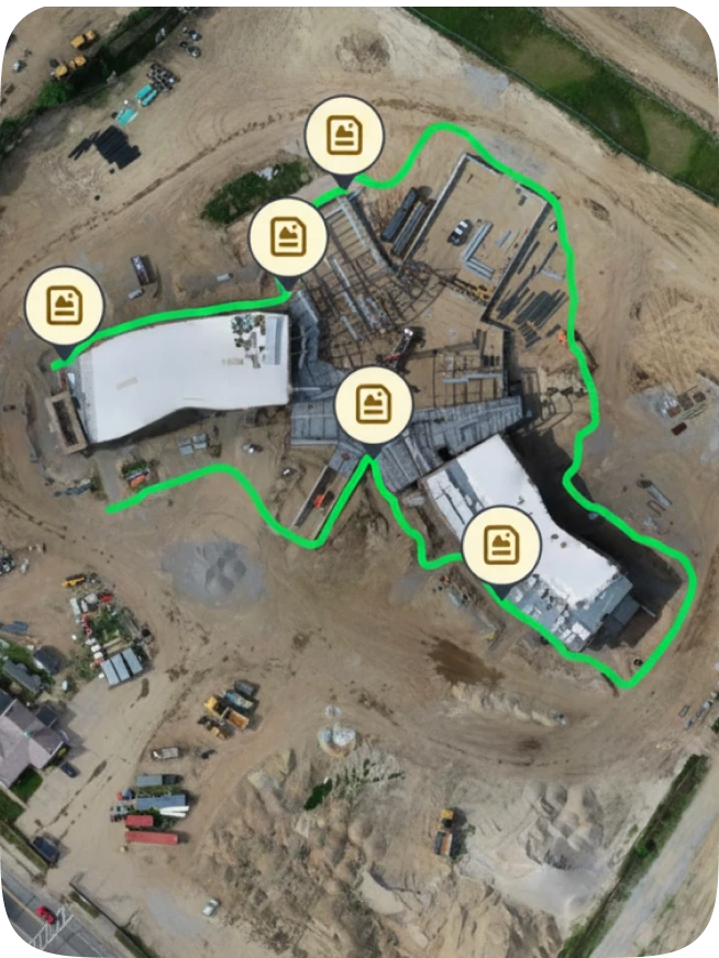
Drone data analysis comes down to two comparisons: the site against its own past, and the site against the drawings. Both help builders extract valuable insights from a processed map and turn them into a decision.
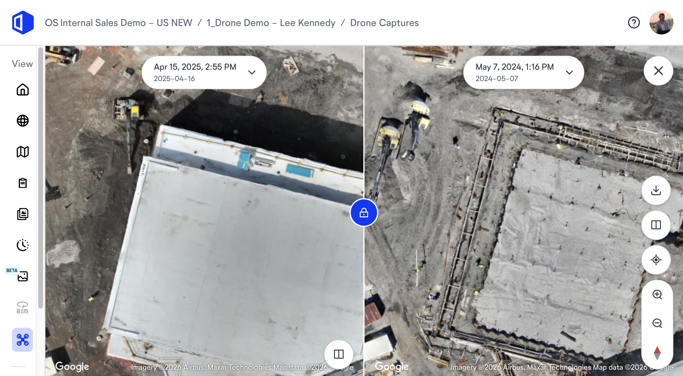
- Compare the site with its past: Split View puts up to four orthomosaics side by side, and two flights show material added or removed.
- Compare the site with the design: Overlay site plans, utilities, and drawings on the orthomosaic, then measure distances, slopes, areas, and cut/fill volumes where conditions drift.
Two common uses sit on top of these comparisons:
- Earthwork and stockpiles: measure cut/fill and stockpile volumes between flights.
- Progress and logistics: confirm what changed since the last flight and plan laydown and access.
Engineers can carry georeferenced outputs into geographic information system (GIS) and design workflows and continue the geospatial analysis in the software already on the desk.
Why run quality checks before measuring?
Run quality checks on the model before anyone measures from it, because a finished orthomosaic can still hide high reprojection error or weak control. A measurement is only as defensible as the checks behind it.
“Before I measure anything, I open the processing report and look at how well the cameras solved and whether the control held. A map can look sharp and still sit far enough off that a stockpile volume comes out wrong. The check most teams skip is a known distance. Pick something on site you’ve already measured, like a slab edge or a curb line, measure it on the map, and see if the two agree. If they don’t, hold off on every other measurement from that flight.”
—Jess Lam, Product Manager, OpenSpace
Why does drone mapping depend on flight-to-flight alignment?
Drone mapping depends on alignment because change shows up only when two flights land on the same spot on the ground. Drone technology has made aerial mapping routine. The second flight earns its place only when it tells you something the first one did not. A sharp orthomosaic that sits off last month’s map shows movement that never happened, and a cut/fill comparison built on it measures drift instead of earth moved.
How do virtual control points keep flights aligned?
Virtual control points keep flights aligned by locking captures from different flights to the same location without survey equipment. Advanced features like this fix drift, so each new flight lines up with the last. For the full path from flight plan to delivery, see this guide to drone mapping in construction.
How do you build an aligned flight series?
Build an aligned flight series in four steps, because one orthomosaic records how the site looks while a series of aligned ones shows what changed.
- Fly the same mission on a steady rhythm.
- Process each flight and compare it with the last one.
- Share the result with the people who act on it, so decision making stays tied to current conditions.
- Keep every flight in one record.
Over time that record of aerial data supports asset management after turnover, with aerial and ground capture in one place.
“One flight shows you what the site looks like. The second flight shows you what changed, and that’s where the decisions are. With two aligned flights, a team can see how much material left a stockpile or whether the laydown area crept into an access lane. The teams I’ve seen get the most from drones fly on a schedule, because each new map can be measured against the last one instead of admired on its own.”
— Jess Lam, Product Manager, OpenSpace
See your flights line up. Book a demo to see OpenSpace Air process a flight and align it with the previous one.
How accurate does drone imagery need to be?
Drone imagery needs to be as accurate as the decision it supports. Flight design and ground control drive accuracy, and each class of decision needs a different level.
| Decision tier | Examples | What drives accuracy | Who signs off |
| Site awareness and progress | Logistics, sequencing, progress records | Repeatable flights and aligned captures | Superintendent or project manager |
| Quantities and earthwork | Stockpiles, cut/fill, grading checks | Overlap, ground control points (GCPs) or a real-time kinematic (RTK) drone, and model quality checks | Project engineer, with surveyor review |
| Survey-grade deliverables | Boundaries and legal records | Surveyed control and independent checkpoints | Licensed surveyor |
The ASPRS Positional Accuracy Standards for Digital Geospatial Data set the reference for the third tier, and Edition 2, Version 2 added a dedicated addendum for mapping with unmanned aerial systems.
What should drone photogrammetry software do for builders?
Drone photogrammetry software should do the heavy processing for you and put results in front of the people who decide. Accuracy tiers set what the software has to support, so check six things when comparing platform capabilities:
- A superintendent can start processing without photogrammetry expertise.
- Imagery from the drones already on site works as is.
- Flight alignment holds across visits.
- Aerial imagery connects to ground capture and plans, enabling collaboration in one place.
- Results export in multiple formats for GIS and design workflows.
- A user-friendly interface lets project managers and owners open results without pilot training.
What does OpenSpace Air do?
OpenSpace Air is drone data processing software built into the Visual Intelligence Platform. Upload images from any drone, and OpenSpace Air processes them into orthomosaics, elevation models, 3D meshes, and point clouds.
How does Suffolk use aerial and ground capture together?
Suffolk pairs ground capture for field-level detail with OpenSpace Air for site-wide context, as Suffolk’s case study describes. Adam Fyrer, Senior Associate, Construction Technology at Suffolk, said, “OpenSpace Air gives us a true bird’s-eye view of the entire site.”
Talk through your drone workflow. Tell the OpenSpace team which drones and export formats your project uses, and get a clear answer on how OpenSpace Air fits.
Frequently asked questions
Do you need a license to fly a drone on a construction site?
Yes, commercial flights fall under the Federal Aviation Administration’s Part 107 rules, which require a remote pilot certificate or direct supervision by someone who holds one. Each drone must be registered, and flights stay at or below 400 feet above ground level unless the drone remains within 400 feet of a structure. State and local laws on trespass, privacy, and takeoff and landing sites can still apply, so check them before the first flight.
Is photogrammetry or LiDAR better for construction sites?
Photogrammetry fits open sites and routine progress work, and LiDAR earns its higher cost under dense vegetation or on complex terrain. Photogrammetry builds maps, models, and point clouds from ordinary camera images that most commercial drones capture, while LiDAR uses laser pulses to measure distance and needs specialist equipment. OpenSpace Air processes JPG images with GPS data.
What drones and image formats work with OpenSpace Air?
OpenSpace Air works with any drone, including DJI and Skydio models, flown by hand or on an automated mission. It accepts JPG images with GPS data. Upload the flight, and processing starts.
What export formats does OpenSpace Air offer?
OpenSpace Air offers multiple export formats, including GeoTIFF and OBJ for processed outputs and CSV for area and volume results. Engineers carry them into GIS and design workflows. Check the formats your engineers need before the first flight.
Pair every flight with ground capture and plans in one record, and the next decision starts from what the site looks like today.