Every drone flight on a construction site produces hundreds, sometimes thousands, of raw images. Capturing that imagery is only the first step. Turning them into something useful is where the real value begins.
Drone imagery processing turns raw captures into usable project data. It’s where images become orthomosaics, point clouds, and 3D meshes. And where measurements become defensible and progress comparisons become possible.
The global construction drone market was valued at $4.6 billion in 2024 and is projected to reach $7.1 billion by 2030, according to Research and Markets. That growth reflects real adoption across jobsites. Whether that adoption delivers is a processing question.
What is drone imagery processing in construction?
Drone imagery processing is the computational pipeline that converts geotagged, overlapping images captured during a drone flight into georeferenced deliverables builders can act on. The drone collects the raw material. Processing software does the work of aligning, stitching, and interpreting it.
The pipeline produces four core output types: orthomosaics, point clouds, 3D meshes, and digital elevation models (DEMs), each suited to a different construction workflow.
This is a discipline that straddles remote sensing, photogrammetry, and construction operations, and the terminology reflects that. Ground control points (GCPs), ground sampling distance (GSD), and relative accuracy are surveying concepts, but their implications are project management realities. A processed dataset that isn’t accurate enough to support cut/fill decisions, or one that exists in a separate platform nobody checks, doesn’t move the project forward.
Construction teams are increasingly bringing aerial imagery and ground-level 360° captures into the same environment, rather than managing them in separate tools. For a broader introduction to how reality capture works across capture methods, see our guide on Reality Capture 101.
The drone imagery processing workflow, step by step
Processing begins well before the drone leaves the ground. Each stage in the workflow affects what’s possible at the next.
Flight planning
Flight planning determines image overlap, altitude, and coverage area. For construction photogrammetry, higher overlap produces more accurate outputs but increases image count and processing time.
Altitude controls ground sampling distance (GSD): lower means higher resolution, but more images and longer processing time. High winds on flight day can introduce motion blur and reduce usable images, which affects the quality of the final products. Planning software sets flight lines automatically once the operator enters the parameters.
Ground control points & image capture
Ground control points (GCPs) are physical markers placed at known coordinates across the site, used to anchor the photogrammetric model to real-world coordinates. More GCPs improve accuracy assessment results, particularly for elevation data.
On sites where drones are equipped with RTK (real-time kinematic) or PPK (post-processing kinematic) GPS, teams can reduce or eliminate GCPs for progress monitoring workflows, though survey-grade deliverables typically still require them.
Images captured during the flight carry embedded GPS coordinates that the processing software uses to align and stitch the dataset.
Upload & image processing
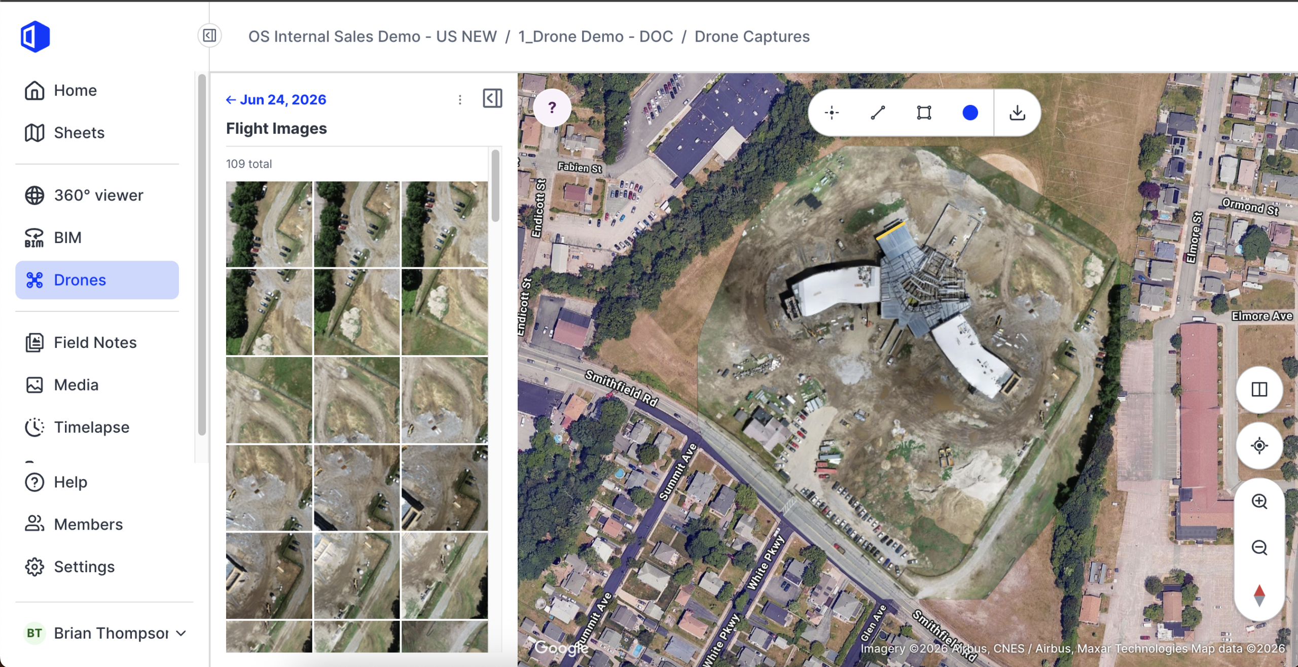
After the flight, images transfer from the SD card to the processing software, either on a local workstation or via cloud upload. Cloud processing can remove the need for specialized local hardware and make outputs easier for project teams to access..
OpenSpace Air, for instance, processes drone imagery without requiring specialist photogrammetry expertise. Upload the images from your flight, and OpenSpace automatically processes them in hours into outputs such as orthomosaics, point clouds, and 3D meshes. The platform is drone-agnostic, so teams can use the drone and flight planning app that fit their workflow.
Output validation & accuracy assessment
Processing software produces a quality report alongside the outputs. That report covers tie point density, GCP residuals, and reprojection error. These are the numbers that tell you whether the dataset is reliable enough for the intended use. A point cloud that looks visually complete but carries high reprojection error isn’t suitable for precise measurement. Accuracy assessment at this stage prevents downstream disputes.
What outputs does drone imagery processing produce & how accurate is it?
Processed flights produce several distinct outputs, each suited to different tasks on the project.
- Orthomosaics: Georeferenced, stitched top-down images used for progress overlays, drawing comparisons, and site logistics planning.
- Point clouds: Dense 3D datasets used for volumetric measurement, earthwork analysis, and as-built verification. Project teams can also export point cloud outputs to BIM workflows.
- 3D meshes (textured models): Photorealistic 3D representations of the site used for stakeholder communication and facade inspection.
- Digital elevation models (DEMs): Elevation heatmaps used for cut/fill analysis, drainage assessment, and grading verification.
Accuracy depends on several variables. GSD, the real-world size each pixel represents, is the primary resolution metric. Horizontal accuracy typically runs at one to three times the GSD; vertical accuracy at one to five times. At a standard survey altitude of 60 to 120 meters above ground level, construction-grade GSD values of 2 to 5 centimeters per pixel are achievable.
RTK-enabled drone photogrammetry delivers direct georeferencing accuracy suitable for construction and engineering use, as confirmed by ISPRS Annals research published in 2024.
Flight altitude, camera specifications, and overlap settings all influence GSD and how usable the final products are for site decision-making. Multispectral images from sensor-equipped drones can add a further layer of analysis for specific features like vegetation management or thermal surveying on industrial sites, though most commercial construction workflows rely on RGB imagery.
“The quality report is the step most teams skip. They see a complete orthomosaic and assume the dataset is good. But reprojection error and GCP residuals tell you whether those measurements are actually defensible—and if you don’t check them before you hand that data to the engineer or the super, you’re setting up a dispute you could have avoided on the front end.”
—Jess Lam, Staff Product Manager, OpenSpace
Why the processing platform matters as much as the drone
The drone is visible. The processing platform is not. That’s part of why construction teams invest in hardware and underinvest in where the imagery goes afterward.
The fragmentation problem looks like this:
- A crew flies the site and downloads images to a local workstation
- Images are processed in dedicated photogrammetry software like Agisoft Metashape
- Outputs are exported and uploaded to a file-sharing service or separate viewing platform
- Links are sent to the project team
At each transfer point, context is lost, version control breaks down, and the gap between capture and decision widens. Agisoft Metashape produces high-quality outputs and gives experienced users precise control over processing parameters, but it assumes a trained operator and a deliberate export workflow. That’s appropriate for survey-grade deliverables. For progress monitoring at scale across many projects, it introduces friction most construction teams cannot sustain.
Platforms that combine processing with storage and visualization in a single environment eliminate those transfer steps. When orthomosaics, point clouds, and ground-level 360° captures exist in the same platform, project teams can:
- Overlay drawings directly on orthomosaics.
- Run measurements without exporting to a separate tool.
- Share specific views with owners without granting access to an unfamiliar interface.
That integration also matters for access. A processed dataset sitting on a local workstation is accessible to one person. The same dataset on a cloud platform with project-level permissions is accessible to the entire team, including the owner’s representative reviewing progress remotely.
OpenSpace Air brings drone capture directly into the OpenSpace Visual Intelligence Platform. Imagery from any drone uploads directly, processes automatically, and becomes available alongside 360° captures and mobile photos in a single environment. No switching platforms, no manual exports, no orphaned files.
When asked what question construction teams should be asking when evaluating drone imagery platforms that most teams overlook:
“Most builders are asking ‘what outputs does it produce?’ when they should be asking ‘where do those outputs live after processing?’ A point cloud that gets exported to a folder nobody checks isn’t moving anything forward. The question is whether the aerial and ground capture end up in the same environment your project team is already working in — because if they don’t, you’ve solved the flight problem and left the access problem completely untouched.”
—Jess Lam, Staff Product Manager, OpenSpace
From aerial imagery to jobsite decisions
Processed drone outputs earn their value when they connect to actual construction workflows, not when they sit in a viewer.
Progress monitoring
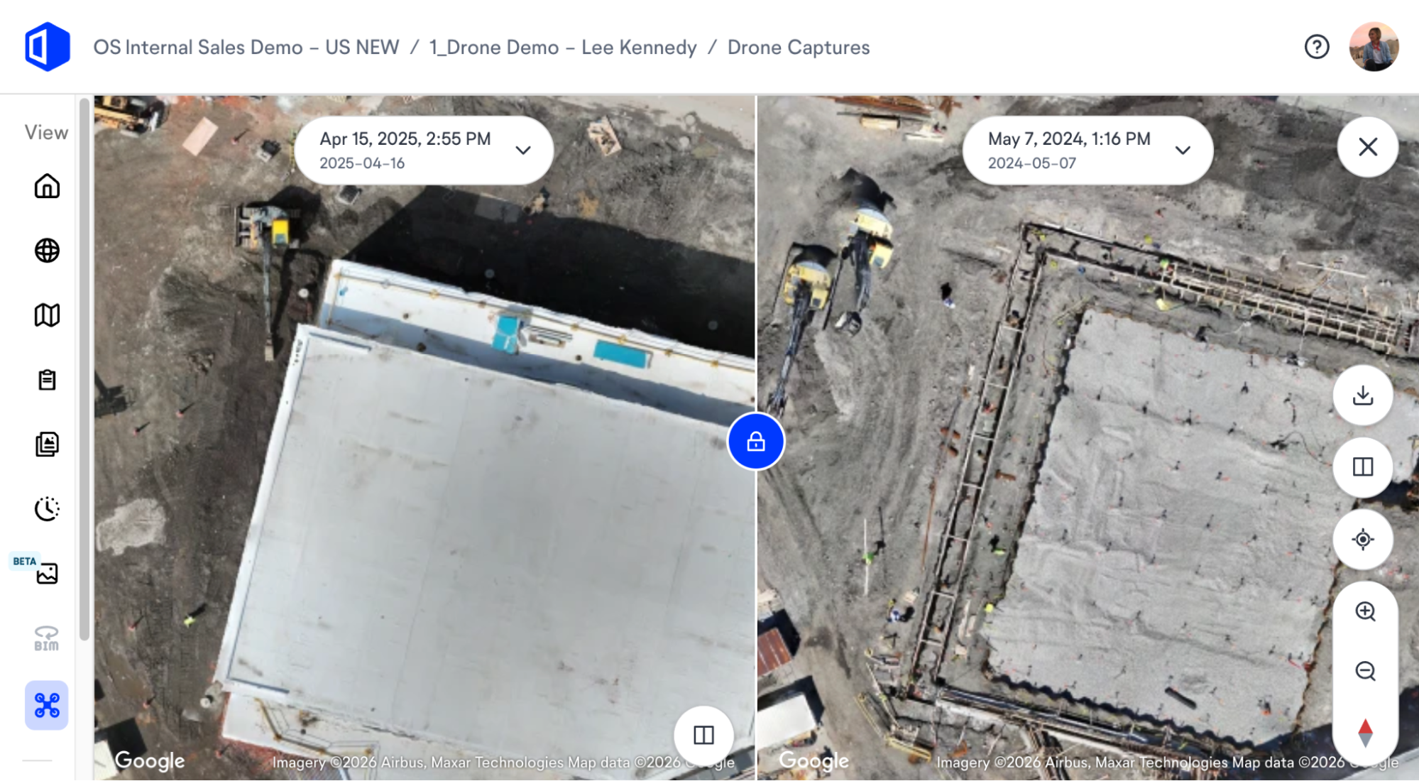
Overlay a site plan or drawing directly on an orthomosaic to compare planned versus actual conditions. Run sequential flight comparisons to track work installed week-over-week. For owners managing capital programs across many projects, this creates an objective visual record that replaces narrative status updates with documented evidence.
Earthwork & volume analysis
Cut/fill analysis from processed drone outputs gives superintendents and project engineers volume measurements in hours rather than days, with capture methods that don’t require a survey crew on the ground. For large grading operations, drone-based photogrammetry tied to an accurate processing workflow is a cost-effective alternative to traditional surveying.
Facade inspection
Processing software creates textured models from overlapping imagery that allow teams to inspect cladding, glazing, and structural elements without lifts or scaffolding. Combined with ground-level 360° documentation, the aerial and ground perspectives create a complete picture of the building envelope at any point in the project.
Change detection
Multi-flight orthomosaic comparisons in a platform with overlay tools give project teams a reliable method for identifying deviations early rather than discovering them at inspection or closeout.
See how OpenSpace Air fits your drone program: request a demo.
Frequently asked questions
How long does drone image processing take?
Processing time depends on image count, processing software settings, and whether computation runs on a local workstation or in the cloud. A standard construction flight of 300 to 500 images typically produces orthomosaics, point clouds, and 3D meshes within two to four hours on a cloud platform. Local workstation processing on the same dataset takes longer and depends heavily on hardware.
What is the difference between an orthomosaic and a 3D mesh?
An orthomosaic is a geo-corrected, stitched top-down image of the site. It is two-dimensional, carries real-world coordinates, and supports measurement and overlay workflows.
A 3D mesh is a textured 3D model of the site reconstructed from the same images.
Both come from the same photogrammetric processing pipeline, but they serve different workflows: orthomosaics for progress tracking and drawing comparisons, meshes for volumetric visualization and facade inspection.
Can drone imagery be processed on any platform, or does dedicated processing software apply?
Converting raw drone images into survey-quality output products requires dedicated photogrammetry software. The two most widely used options are Agisoft Metashape and Pix4D Mapper. Agisoft Metashape is a desktop application that gives experienced operators detailed control over processing parameters.
OpenSpace Air automates the same pipeline in the cloud, removing the need for specialist software knowledge while producing orthomosaics, point clouds, and 3D meshes directly in the construction management environment.
What is GSD & why does it matter for construction drone programs?
GSD, or ground sampling distance, is the real-world size each pixel represents in a drone image or processed orthomosaic. At 3 centimeters GSD, each pixel in the output corresponds to a 3-centimetre square on the ground. Lower GSD means higher resolution and more precise measurement capability. For construction progress monitoring, GSD values of 2 to 5 centimeters are typically sufficient. Survey-grade workflows requiring precise volume or elevation accuracy target finer GSD and use GCPs to anchor the coordinate system.
Related topics in construction reality capture
Aerial imagery is one layer in a complete Visual Intelligence program. Ground-level 360° capture, mobile documentation, and BIM comparison workflows connect to the same platform. The teams getting the most from drone programs aren’t treating aerial imagery as a separate workstream. They’re running it alongside ground capture in a single environment where every image, every output, and every comparison is available to the full project team without friction.
The drone survey world has matured. The industry has standardized flight planning. Drones are accessible. The remaining variable is what happens between the flight and the decision. That’s a processing and platform question, and it’s the one worth getting right.
Ready to see OpenSpace Air in action? Request a personalized demo.