For the launch of new OpenSpace Air, we had the privilege of sitting down with early customer Adam Fyrer, Construction Technology Deployment Associate at Suffolk Construction. Adam shared Suffolk’s history with drones and how his team now uses OpenSpace to consolidate all their field documentation into one solution—360° captures and drone mapping & imagery in the same platform.
Plenty of builders are in the same position as Suffolk—they have relied on drone surveying for years, but the outputs lived in a tool disconnected from the rest of the project record.
We invite you to watch the entire OpenSpace Air webinar on demand (it runs just around 30 minutes), but in this blog we’re sharing questions and answers from the lively chat during the event.
Drone hardware and best practices
Do you recommend any particular drone when starting out?
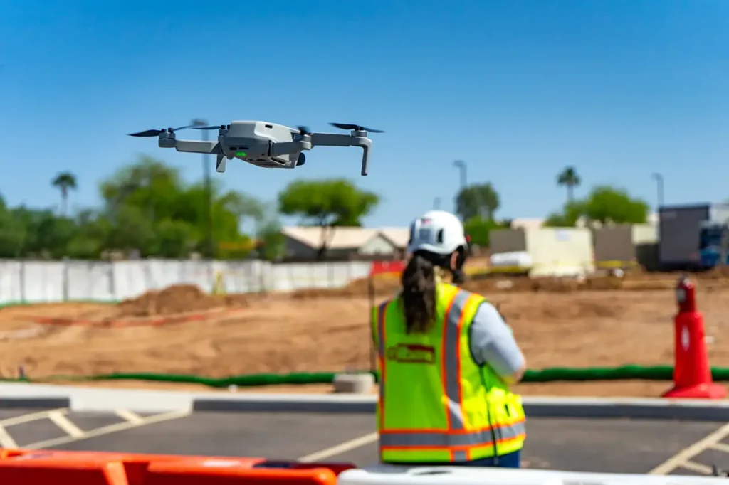
OpenSpace Air is drone agnostic, meaning you can use any drone that captures georeferenced images. OpenSpace Air works with any JPG images with GPS data captured by any drone or drone app. Images can be processed into orthomosaics, point clouds, and 3D meshes or pinned to the map as additional images. Both manually captured or images from automated flights work. We’re seeing many customers adopting the Mavic 3E, but note this drone is on the more expensive side if you’re not sure you’ll be flying regularly.
Is there a minimum size or weight for a drone?
No, there is no required minimum size or weight required for OpenSpace Air. Be sure to follow local and federal regulations in your area.
Do pilots flying drones under 250 grams still need a license for commercial use?
Yes. Using a drone for commercial purposes requires a license.
Is an 8K camera drone sufficient quality?
More than sufficient. For example, customers are seeing great results with the Mavic 3E, which has a 4K camera with a robust lens and 20 megapixels.
Do the drones need RTK?
OpenSpace Air supports real-time kinematic positioning (RTK) integrated drones but does not require RTK. The RTK data is stored as metadata in the images, which increases the GPS accuracy.
For drones with waypoint flight planning, what height-to-overlap ratio do you recommend?
We recommend following the flight app’s recommended ratio. For best results, capture a minimum of 75% overlap and 65% sidelap. Learn more in our Drone Capture Best Practices Support article.
Is there a way to increase image quality?
Image quality is dependent on the drone and camera you’re using. Some drones allow you to adjust image settings using the drone manufacturer’s app.
What are the recommended settings to get higher quality 3D outputs?
With most photogrammetry engines, the images you use, the angle, differences in elevation, and overall coverage can have an effect on the processing outputs. For higher quality 3D meshes and point clouds, we recommend capturing oblique images with a camera angle of 30°-45° to get more detail of vertical faces. Find more information in our Drone Capture Best Practices Support article.
Can you upload images from the drone remote control or SD card into OpenSpace Air?
Yes, you can download images from the controller or SD card to your computer, and then upload into OpenSpace Air. Follow these steps for uploading drone images.
OpenSpace Air access and features
Is there an additional cost to use OpenSpace Air for existing OpenSpace customers?
Any company with an active OpenSpace Capture subscription has access to OpenSpace Air drone mapping software at no additional cost, including on projects where you are not using OpenSpace Capture. Drone image processing for maps and 3D outputs is available on unlimited projects. The integration of these two solutions ensures that all your site data—whether captured via drones or 360° cameras—is centralized in one platform, making project tracking and analysis more efficient.
Can OpenSpace Air use AI/machine learning yet?
There are a number of AI models running in the background in OpenSpace and more to come.
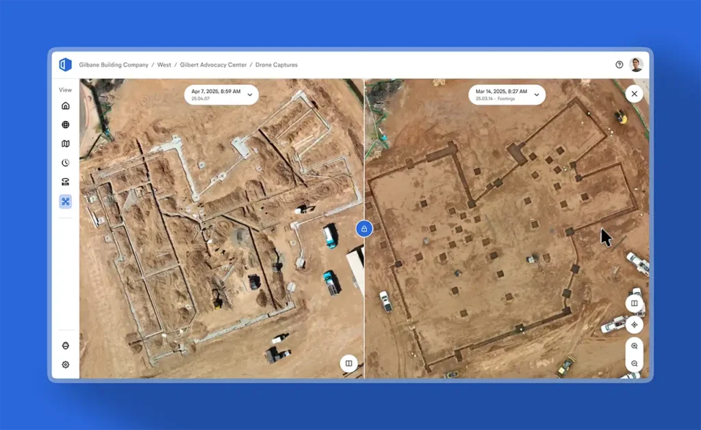
How do you overlay using OpenSpace Air (versus side by side)?
In OpenSpace Air, you’ll find an overlay menu on the left side. Use that menu to upload PDF files you can use as overlays over your processed orthomosaic images. This feature is great for determining if work is going according to plan. Follow this step-by-step guide to get started with overlays.
Can you communicate and collaborate between users in OpenSpace Air?
Yes, your uploaded drone captures are available to all users with access to the project. OpenSpace Air takes image-based collaboration to a new level. Integrating aerial drone data into OpenSpace gives you a one-stop shop for a complete picture of your jobsite. Now, in addition to imagery from 360° cameras, mobile devices, and laser scanners, you can easily view, manage, and analyze imagery from drones—all on the OpenSpace platform.
Is the Beta phase completed? Can my company join the Beta test?
The initial Beta is complete, but we’ll be launching Beta programs for future features. Let your OpenSpace representative know if you’d like to be included.
OpenSpace Air roadmap
Will you have connections between OpenSpace Air and BIM in OpenSpace—overlapping point clouds with BIM files?
This functionality is something we’re currently exploring—with the goal of ensuring all files can be viewed in the same environment/screen. Stay tuned for updates.
Will we be able to do comparisons in 3D mode (similar to how you can compare 3 or 4 different captures now in 2D mode)?
We do not currently support comparisons in 3D mode, but it’s a great idea! We passed this feature request along to our product and development team.
I saw that you can add additional images to the drone captures. Do the images need to be standard images, or can they be 360° captures?
For now, we support standard 2D images, but 360° photos will be supported later this year.
What about laser scans in OpenSpace Air?
With OpenSpace BIM+, you can already bring point clouds from laser scanners into OpenSpace. We may explore the ability to bring point clouds into OpenSpace Air in the future.
Does OpenSpace Air have cut/fill and measure tools?
These features will be available in an upcoming update.
Any plans for vertical facade inspections?
Yes—this is something we’re exploring for delivery later this year.
Do you plan to add an option for manual georeferencing for more accurate spatial positioning?
Yes, we plan to ship georeferencing capabilities later this year.
Do you have plans to adopt drone stations?
We’re actively monitoring drone station adoption. If your team is using them—or plans to—please let your OpenSpace representative know.
Learn more about OpenSpace Air
- OpenSpace Air on-demand webinar
- OpenSpace Air product page
- Support articles
- Blog post: OpenSpace Air launch
- OpenSpace Academy online course
Get a demo
We’re happy to talk to you about implementing OpenSpace Air on your projects. Request a demo now!