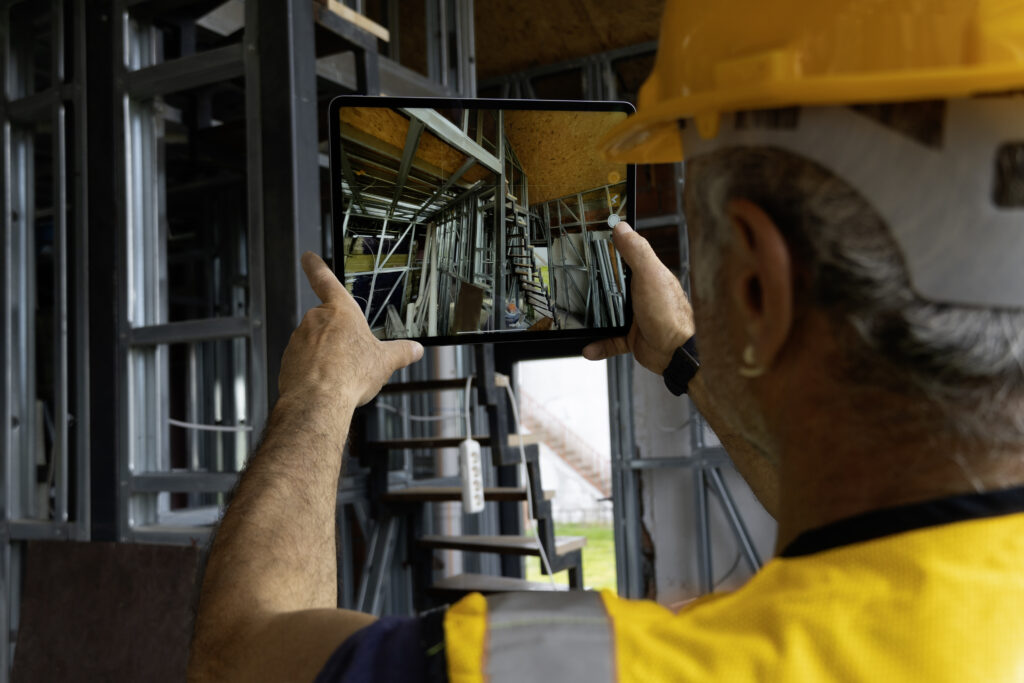
Construction surveying is the practice of measuring, marking, and verifying where every element of a construction project sits relative to the design plans. It covers three separate jobs: establishing control, staking out the work before construction begins, and confirming what actually got built.
Most guides treat all three as one discipline with one accuracy standard, and that is where budgets and schedules quietly break. Specify survey-grade precision for every measurement and a project pays for work nobody needed.
Specify none, and a crew closes drywall over an error that surfaces at closeout. The useful question is which grade of accuracy each job on a construction site actually requires.
What is construction surveying?
Construction surveying is the process of translating design plans into physical marks on the ground, then verifying that the structures built against those marks match the design. Surveyors establish horizontal control and vertical control points, set reference points a crew can build from, and later determine whether existing site conditions match the drawings.
The work splits into three jobs that share a name and little else:
- Land surveys establish property lines, existing easements, and land use constraints before construction design is locked in.
- Construction staking transfers those drawings onto the site so crews know the exact location of footings, columns, and utility lines.
- As-built surveys record what was installed once the work is completed, producing the detailed report that owners, contractors, architects, and engineers rely on at handover.
Deformation surveys sit alongside these three, monitoring structures for movement during and after construction.
A construction surveyor is a licensed land surveyor whose scope is the build itself rather than the property transaction. Building surveyors, by contrast, typically work on existing buildings and completed structures. Each job answers a different question. Each tolerates a different margin of error.
The three accuracy tiers behind every site survey
Every measurement on a construction site belongs to one of three accuracy tiers, and confusing them is the most expensive mistake in the surveying process. The USIBD Level of Accuracy specification formalizes this, defining five tiers that run from rough space planning down to forensic precision.
The BIMForum Level of Development specification makes the same point from the other direction. It stops at LOD 500 and declines to define as-built accuracy, handing that question to a separate standard. That unclaimed handoff is where most projects lose the thread.
| Tier | The job | Who owns it | What it demands |
| Survey grade | Control stations, property lines, construction staking | Licensed surveyors | Total stations or GNSS, legal accountability, sign-off by a licensed surveyor |
| Measurement grade | Earthwork quantities, grading, elevation checks | Survey and VDC teams | Aerial or terrestrial capture tied to control points |
| Evidence grade | Verifying installed work against design plans | Field and VDC teams | Frequent, dated, spatially located visual data |
Survey-grade work cannot be delegated to software. Evidence grade cannot wait for surveyors to come back. Treating the second as though it needed the first is why so many builders verify nothing between scheduled visits, and why so few projects require anyone to own the middle ground.
When asked what construction teams are really asking when they question the accuracy of OpenSpace captures, and where a licensed surveyor remains essential, Michaela Rhile, Product Manager of OpenSpace says:
“The question behind the question is usually about risk. People hear ‘accurate’ and think about decimal places, when what they need to know is what happens if the number turns out to be wrong. A boundary line that is wrong costs you a lawsuit, so that work stays with a licensed surveyor and always should. A ceiling you can no longer see into costs you a demo and a re-install, and there what matters is having a dated record at all. I grew up around a general contracting business. The expensive mistakes were rarely the ones somebody measured carefully and got slightly wrong. They were the ones nobody measured at all.”
—Michaela Rhile, Product Manager, OpenSpace
Construction surveying methods & the instruments a construction surveyor uses
A construction surveyor selects an instrument based on the accuracy tier the job demands, not on what is newest.
| Method | What it captures | Accuracy tier | Best fit |
| Robotic total stations | Horizontal and vertical angles from fixed instrument setups | Survey grade | Layout, control, legally defensible measurement |
| GNSS and RTK receivers | Position across open ground, quickly | Survey to measurement grade | Site work, drainage patterns, rough grading |
| Terrestrial laser scanning | Dense point cloud data | Measurement grade | Existing buildings and retrofits where elevation and clearance have to be exact |
| Photogrammetry | The surrounding environment, from overlapping images | Measurement grade | Earthwork, stockpiles, and open sites |
| Ground-level 360° capture | Interior conditions on a fixed rhythm | Evidence grade | Verification between visits, as-built records |
Which instrument a construction surveyor reaches for depends on what the survey data has to prove: elevation, location, or clearance. No method replaces another. Total stations cannot document a ceiling before it closes, and a walked capture cannot establish a control point.
From control points to construction staking: how the surveying process runs on a construction site
The surveying process runs in a fixed sequence, and each handoff either preserves accuracy or loses it.
- Topographic survey. A survey conducted before design confirms boundaries, zoning limits, and terrain, often alongside geological surveys of soil type and soil composition.
- Control. Surveyors establish the horizontal control, the vertical datum, and the control points that every later measurement references.
- Construction staking. Survey stakes and offset stakes mark the exact location of new structures, foundations, and infrastructure against the approved plans.
- Verification. Once construction work starts, those stakes disappear under excavation and site traffic within days.
From that point on, most site survey work is verification rather than layout, and this is the part of the construction process that projects staff the least. Verification between scheduled visits rarely reaches a construction surveyor at all, so infrastructure, structures, and building systems get built on marks nobody has re-checked.
Why does the site survey record go stale between visits?
A site survey confirms conditions on the day the crew shoots it, and the construction site changes every day after. The gap that follows is an ownership problem more than a documentation problem, because nobody has been assigned the evidence-grade tier.
Most construction surveying budgets fund the first tier and quietly assume the third takes care of itself once the work is built.
Three failure modes follow:
- Unverified layout. Work gets built on before anyone on the project checks it against the reference points.
- Unescalated drift. Deviation accumulates and nobody raises it, because raising it means booking surveyors.
- Wrong design plans. The drawings turn out to have been wrong before anyone measured anything, which no amount of re-shooting the same points will catch.
How reality capture changes the work of a land surveyor on-site
Reality capture does not replace land surveyors. It changes what gets escalated to them. A 360° walk of a construction site produces a dated, spatially located record of existing conditions, and reality capture technology maps every frame to the floor plan automatically through the OpenSpace Spatial AI Engine.
Questions that used to trigger a callback, such as whether a sleeve landed at the location the drawing specified, now get answered from a walk that already happened.
OpenSpace is the Visual Intelligence Platform for builders, and the line it draws is a clean one. Surveyors keep the legal record. The capture keeps the running one. What remains for licensed professionals is the work that needs a license: control, staking, and any measurement carrying legal weight.
Routine confirmation comes off their plate, which frees survey capacity for the work that genuinely requires it. On major construction projects, that reallocation matters more than any single measurement. Skilled surveyors are the scarce resource, and other factors such as weather and access already limit how often they mobilize.
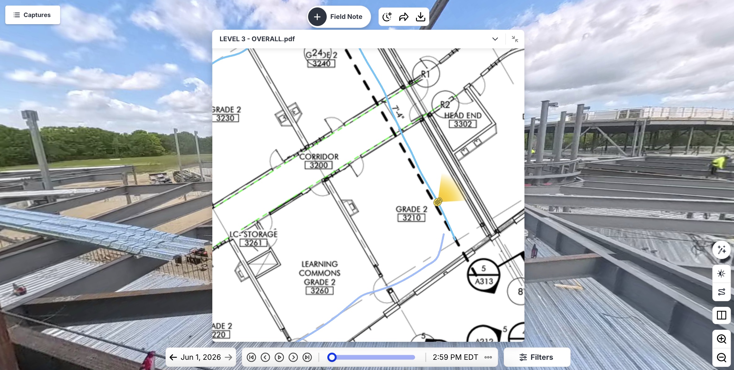
See what a single walk can answer. OpenSpace Capture turns a routine site walk into a dated, mapped record your team can measure against.
How do building surveyors verify as-built conditions against design plans?
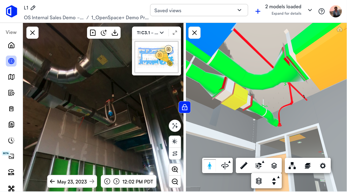
Building surveyors verify as-built conditions by comparing a dated capture of the site against the model or the plans, then logging any deviation as a tracked issue. OpenSpace BIM+ places site conditions beside the BIM model in a split view, so a reviewer can inspect a ceiling or a wall cavity before it closes.
The direction of the error is often the opposite of what builders expect. At U.S. Engineering, Quality Control Manager Chad Lucks noticed in BIM Compare that a section of piping and valves present in the model was missing from a ceiling. He raised a Field Note, assigned it to the VDC technician, and linked it to Procore. The team confirmed the error sat in the as-builts, and the drawings were corrected.
Catching the discrepancy before the ceiling closed saved U.S. Engineering thousands in rework, and Lucks estimates the remote review habit saves him as much as 10 hours per week. Once a floor is completed, that capture carries forward into the as-built deliverable contractors hand the owner.
When asked how often a BIM Compare discrepancy reveals an error in the model or as-built drawing rather than the installed work, and how VDC teams should respond once they recognize that, Molly Taylor, Senior Product Manager of OpenSpace says:
“Teams assume a discrepancy means somebody installed something wrong. Often the install is fine and the model is stale. Once a VDC team accepts that the model is a claim rather than a fact, the review changes. You stop asking whether the field followed the drawing and start asking which record is older. That question gets a lot easier to answer when a dated capture is sitting next to the model.”
—Molly Taylor, Senior Product Manager, OpenSpace
Aerial site analysis for earthwork, land use, and site-wide quantities
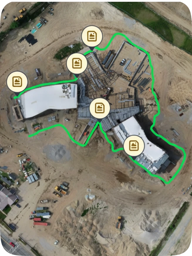
Aerial capture earns its place on measurement-grade work: cut and fill quantities, stockpiles, grading, and analysis across surrounding land. OpenSpace Air produces orthomosaics, elevation models, and point cloud data, with virtual control points for alignment and elevation calibration.
Elevation models let builders compare grading plans against actual grade without sending surveyors back for another topographic survey.
Accuracy depends on ground control and flight planning rather than the aircraft, and commercial flights in the United States require a remote pilot certificate under FAA Part 107.
Environmental conditions play a vital role too, since heavy rain will ground a flight on the day the numbers are due. For a fuller treatment, see how a drone construction site survey fits into project delivery.
When asked which single control-point or flight-planning mistake most often makes an aerial capture unusable for earthwork quantities, and how teams can catch it before they need the data, Jess Lam, Staff Product Manager of OpenSpace says:
“The failure is almost never the flight. It is the control. Teams put ground control points in a tidy cluster near the trailer because that is where it is easy to walk, then wonder why their cut and fill numbers drift at the far end of the site. Control has to bracket the area you care about, horizontally and vertically. The fix is boring and it works. Shoot one known point you did not use in processing, then check the model against it. If that check fails, you find out on flight day instead of the week the earthwork invoice shows up.”
—Jess Lam, Staff Product Manager, OpenSpace
Building a construction surveying process the construction industry can defend
A defensible process assigns an owner to all three accuracy tiers, not only the one a licensed land surveyor signs. Five decisions separate projects that hold up from projects that argue later:
- Specify tier by deliverable. Write the required accuracy tier into the contract rather than assuming one standard covers every measurement.
- Keep survey-grade work with surveyors. Control stations, staking, and property line work stay with the surveyors of record.
- Capture on a fixed rhythm. Interior conditions get documented on schedule, so verification never depends on booking a return visit.
- Define the escalation line. Determine in advance what goes to surveyors and what gets resolved from a capture.
- Retain the record through closeout. The survey data collected during construction still answers questions once the structures are completed and occupied.
Minimizing errors on a construction project has less to do with precision than with matching precision to the job. Architects, engineers, contractors, and surveyors all read the same drawings, and a shared visual record is the essential part that keeps their versions of the site aligned.
Talk to an OpenSpace expert or request a demo.
Frequently asked questions
Who is responsible for construction surveying, the owner or the general contractor?
Responsibility usually splits by survey type. Owners typically commission land surveys before design, while general contractors carry construction staking and layout verification through the build. Contracts vary, so the split should be confirmed in writing before mobilization.
What is the difference between a construction survey and an ALTA/NSPS land title survey?
An ALTA/NSPS land title survey documents legal boundaries, easements, and title matters for a real estate transaction, prepared by surveyors to a national standard. A construction survey supports the build itself, covering layout, control, and verification of installed work. The first protects a purchase, the second protects a schedule.
Does reality capture meet survey-grade accuracy requirements?
Not for legal boundary or control work, which requires calibrated instruments and a professional signature. Reality capture is built for evidence-grade verification: confirming what was installed, where, and when. Pairing the two covers every accuracy tier a project needs.
What drives the cost of a construction survey?
Cost tracks the accuracy tier, the scope of the site survey, and the number of return visits a project requires. Tighter tolerances demand more control, more instrument setups, and more field hours. Cutting repeat visits for routine confirmation usually lowers the total fastest.