Orthomosaics are geometrically corrected aerial images built by stitching hundreds of overlapping drone photos into a single, to-scale map of a site.
On a construction project, that means a measurable view of the earth’s surface from above, updated as often as teams fly. Unlike a satellite layer in Google Earth, which updates on no project-relevant schedule, teams capture a drone orthomosaic on demand and tie it to real GPS coordinates.
For builders managing earthwork, verifying as-built conditions, or documenting scope across a large construction site, orthomosaic maps play a central role in connecting design intent to field reality.
What is an orthomosaic?
An orthomosaic is a composite image built from numerous overlapping photographs captured from an aerial platform. Each image gets corrected for camera tilt, lens distortion, and perspective variation before the final output comes together, so the result has a uniform scale across the entire map.
That correction is the key difference from a standard aerial photo: the orthomosaic accurately represents the earth’s surface as if every point were viewed from directly above.
Standard aerial photos introduce scale variation by design. The center of a frame renders at a different scale than the edges. Camera tilt shifts ground features from their true positions. Orthomosaic maps eliminate those errors through photogrammetry software that corrects for lens distortion and aligns each image based on GPS coordinates, producing accurate maps ready for measurement.
A site photo tells you what something looks like. A drone orthomosaic map tells you where it is, how large it is, and how it relates to everything around it.
How is a drone orthomosaic created? The data processing workflow
Creating orthomosaics starts with automated flight planning software that maps out the drone’s flight path to ensure complete coverage, sets image capture overlap rates, and determines flight altitude relative to the target ground sample distance (GSD).
Higher altitude means faster coverage; lower altitude means high-resolution images that capture fine details on the ground. Flight time is a function of site size and altitude: larger sites at higher altitudes complete faster but yield lower-resolution outputs. High-resolution drone capture can reach less than one inch per pixel, depending on altitude and sensor setup.
During the drone flight, high-resolution cameras capture detailed images across the site. Orthomosaic software programs then process those overlapping images using structure-from-motion algorithms and specialized software built to handle large datasets, with robust image stitching algorithms and error-correction tools that align each frame by GPS coordinates, correct for lens distortion, and stitch the dataset into a single georeferenced output. That data processing stage produces three deliverables:
- The orthomosaic map
- A Digital Surface Model (DSM) or Digital Terrain Model (DTM) for elevation modeling
- A 3D model of site geometry
Accuracy depends on methodology. With RTK- or PPK-enabled drones and proper image overlap protocols, horizontal accuracy within 1-3 centimeters is achievable for most construction applications. Research from the ASCE Journal of Infrastructure Systems confirms that UAS-based surveying delivers reliable accuracy for preconstruction and construction-phase work when proper ground control and overlap protocols are followed.
What makes an orthomosaic map different from standard aerial photos?
The key difference is geometric accuracy. A standard aerial photo is a single perspective capture: scale varies across the frame, topographic relief shifts the apparent position of features. The site is visible, but not measurable.
Orthomosaic maps correct all of that before the final image comes together. Specialized photogrammetry software adjusts each contributing image for camera angle, and topographic relief, then stitches them into a corrected map with uniform scale. One pixel on the left edge represents the same ground distance as one pixel on the right, and that consistency is what makes accurate measurements possible directly on the map.
Google Earth images are not survey-grade, are not tied to current conditions, and are not updated on any construction-relevant cadence. A drone orthomosaic of the same area is a metrically accurate, georeferenced layer teams can mark up, overlay with design drawings, and use to calculate volumes.
How are orthomosaics used in construction site workflows?
Orthomosaic maps support major decisions at every phase of a construction project, from first ground break through final as-built handover. They provide high-resolution, accurate, and up-to-date maps that improve site visibility while reducing the need for crews to enter hazardous or hard-to-reach areas. They also cover large areas at lower cost than traditional survey methods and support more current decisions through frequent updates and real-time monitoring.
That workflow strengthens data collection and analysis across planning, execution, and closeout, not just final documentation.
Earthwork and volume calculations using accurate measurements
Earthwork is one of the clearest construction applications for drone orthomosaic outputs. Combining the orthomosaic image with elevation data from the same drone flight produces cut/fill volumes, stockpile quantities, and grading verification without a survey crew in the field. These precise measurements from point clouds and digital surface models feed directly into Civil 3D and ArcGIS for downstream survey and GIS workflows.
Planned vs. actual overlay for quality control
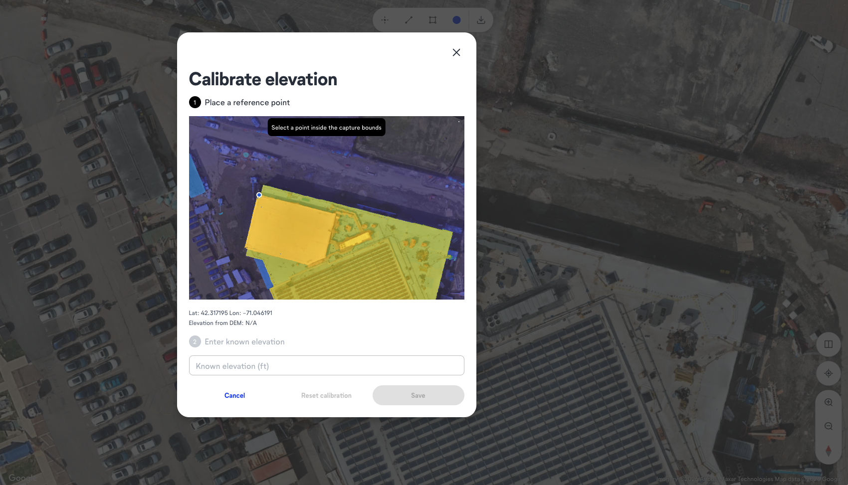
Placing a design drawing on top of a current drone orthomosaic reveals immediately where field conditions diverge from design intent. A concrete pour that landed short of a column line, a grade running higher than the civil drawings, a footprint that has shifted: all appear as visible discrepancies without a manual site walk. The uniform scale of an orthomosaic map is what makes overlay useful as a quality control workflow.
“Waiting for a survey crew to confirm what you already suspect is one of the more expensive habits in construction. By the time someone schedules the survey, mobilizes, and gets results back, the grade is already wrong or the pour has already happened. A drone orthomosaic from day one means the super can pull up the site from Monday’s flight on Wednesday morning, put the civil drawings on top, and see exactly where conditions drifted before the next trade mobilizes. That’s not a reporting upgrade. That’s the difference between catching a problem and paying for it.”
—Wesley DuBose, Product Manager, OpenSpace
As-built documentation across the construction site
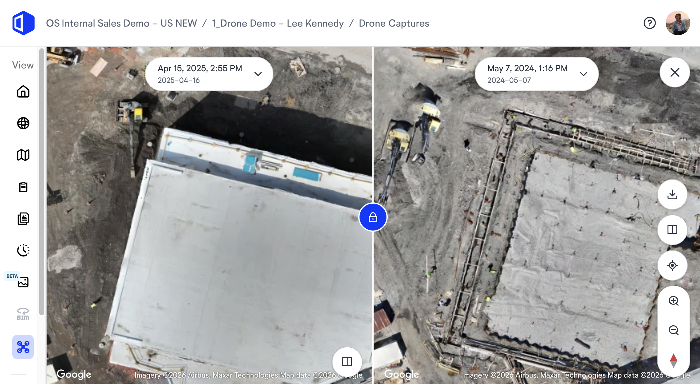
A series of dated drone orthomosaic captures across a project lifecycle builds a chronological, georeferenced record of the construction site for dispute documentation, insurance claims, and design change verification.
A single drone flight documents the full site faster than a ground crew, producing aerial photos with accurate representations of conditions at each point in time. For owners, an orthomosaic map at practical completion is a defensible as-built record they can query and share.
Orthomosaic maps in environmental monitoring, disaster management, & other industries
Outside construction, orthomosaics support agriculture through precision farming for crop monitoring, yield estimation by counting plants and measuring canopy coverage, crop health tracking with specialized sensors that reveal stress, disease, and nutrient deficiencies, and irrigation management by spotting pooling, dry areas, or faulty systems; they also support forest health assessment, environmental monitoring of erosion and land management change, and disaster management response after natural disasters.
In mining and quarrying, they support resource extraction through volumetric analysis of stockpiles and open pits as well as day-to-day operational oversight.
Emergency response teams use quickly processed aerial mapping outputs to assess damage, direct resource allocation, and response efforts in challenging environments. Urban planners also use them for land-use planning and infrastructure development, while environmental scientists track habitat change, deforestation, and wildlife-reserve conditions. The data processing workflow is the same across sectors. For builders, the value depends on what the orthomosaic connects to, not the aerial imagery alone.
What downstream outputs does a drone orthomosaic unlock?
The same drone imagery that produces an orthomosaic map also feeds three additional outputs:
| Output | What it contains | Where it goes |
| Orthomosaic map | Georeferenced, to-scale aerial image | Plan overlays, markup, as-built records |
| Point cloud / DSM / DTM | Dense elevation records | BIM comparison, Civil 3D, ArcGIS |
| 3D model | Full site geometry | Volumetric analysis, design overlay |
All four (including topographic maps generated from the same flight data) export in standard formats (GeoTIFF, LAS, OBJ) and move directly into Civil 3D and ArcGIS without conversion overhead. As future developments in drone processing continue to shorten turnaround times, the gap between flight and usable deliverable keeps narrowing
Explore how OpenSpace Air turns every drone flight into actionable site intelligence.
How OpenSpace Air processes drone orthomosaics for construction teams
Most builders already have a drone. The gap is what happens after the flight. OpenSpace Air is drone mapping software for construction that accepts uploads from any drone and any flight planning software, then processes drone imagery into high-quality orthomosaics, 3D meshes, and point clouds in hours to produce a cohesive orthomosaic map. Virtual control points keep every capture aligned across flights so orthomosaics from different dates sit on the same coordinate system automatically.
Common orthomosaic software options in the market include Pix4Dmapper and Agisoft Metashape, which together help teams create a seamless orthomosaic map, 3D models, and point clouds.
Teams access 2D and 3D accurate measurements directly on the orthomosaic image: linear distance, area, volume, and slope. Overlays place design drawings on drone orthomosaic images to compare planned and actual conditions. The Elevations view visualizes site height records and drainage context from the same imagery. Cut and fill analysis exports move volumetric data into civil and reporting workflows.
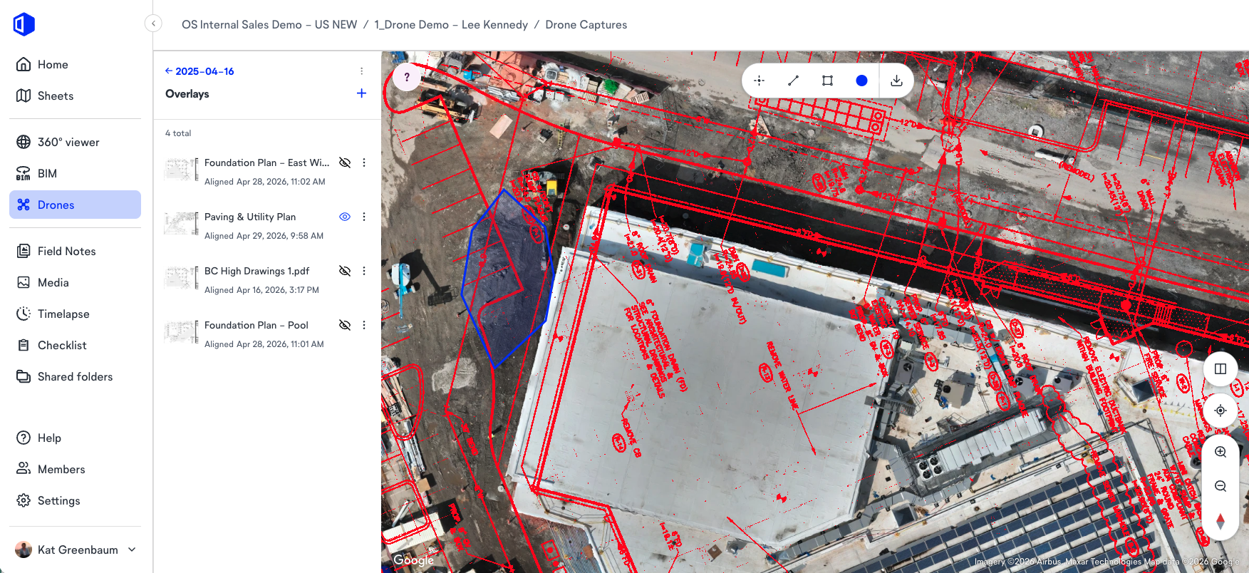
Because OpenSpace Air is part of the same Visual Intelligence Platform as OpenSpace Capture, aerial images sit alongside ground-level 360 imagery on the same floor plan view. Builders get complete coverage of the construction site from ground level and from above in one place.
“A site walk tells you what you can see from where you’re standing. You’re eye level, you’re moving fast, and you’re covering maybe a third of the site if it’s a good day. A plan overlay on an orthomosaic shows you the whole site at once, and it shows you relationships the ground-level view physically can’t. A footing that’s two feet off grid doesn’t look wrong when you’re standing next to it. On the orthomosaic with the civil drawings on top, it’s obvious in about ten seconds. I’ve seen teams walk past problems for two weeks that would have shown up on day one if they’d had the aerial view with the drawings pinned to it.”
—Wesley DuBose, Product Manager, OpenSpace
Why the value of an orthomosaic depends on what it’s connected to
Here is what most orthomosaic content skips: the map is a starting point. Aerial photos and orthomosaic images sitting in a folder, disconnected from design drawings or project schedules, give teams accurate representations of conditions. Reality capture workflows only deliver their full value when connected to the rest of the project record. They do not give teams project intelligence.
Builders getting the most value from drone orthomosaic outputs use them as a layer in a broader platform, where the same imagery that powers earthwork calculations also supports plan overlays, BIM coordination, and construction site documentation for owners and project controls teams.
OpenSpace BIM+ connects drone-derived orthomosaics to design coordination, letting field teams compare design intent against reality without BIM expertise on-site. When builders track progress across project phases with documentation that includes drone orthomosaics, planned versus actual comparisons become measurable and defensible instead of qualitative updates from site walks.
“An orthomosaic on its own is a very accurate snapshot. But accuracy isn’t the same as accountability. When those images live in a separate folder, outside your project record, outside your schedule, outside your documentation workflows, you’ve captured the site and disconnected the evidence. Owners want to know what happened and when. Progress reviews need context, not just imagery. The teams that get the most out of drone documentation are the ones where the aerial record is part of the same system as everything else — so when a question comes up in a meeting, the answer is already there.”
—Michaela Rhile, Product Manager, OpenSpace
Frequently asked questions about orthomosaics in construction
What is the difference between photogrammetry and an orthomosaic?
Photogrammetry is the process; an orthomosaic is one of its outputs. Photogrammetry software analyzes overlapping images to reconstruct geometry and correct spatial distortions using GPS coordinates and camera calibration data. An orthomosaic map is the flat, georeferenced top-down output with uniform scale. The same workflow also produces digital surface models, point clouds, and 3D models.
Can orthomosaics be used for BIM coordination?
Yes. Once the processing workflow georeferences the orthomosaic accurately, teams can place design drawings and BIM elements directly on the aerial image to compare design intent with current site conditions. In OpenSpace Air and OpenSpace BIM+, that comparison extends into 3D model elements, giving field teams a way to verify installed work against the BIM model without specialized BIM expertise on-site.
How often should construction teams capture drone orthomosaics?
Frequency depends on the project phase. During earthwork and grading, weekly drone flight captures are common because volume and grade conditions change quickly and payment milestones depend on verified quantities. During structural and finishing phases, bi-weekly or monthly captures cover progress documentation needs. Capture cadence should align with the reporting schedule so aerial records match the plan comparison periods.
See how OpenSpace Air fits your drone documentation workflow. Talk to an expert.