Building on our image-first foundation, OpenSpace has evolved to provide you more than complete jobsite documentation; we deliver powerful construction coordination tools that put your images at the center of your daily activities. Find what you need and take action with fewer clicks in the field and office.
Field, Design, and BIM Coordination—Simple and Fast
Let’s take a walk through some tasks project team members might face in a day and how OpenSpace can help you better coordinate.
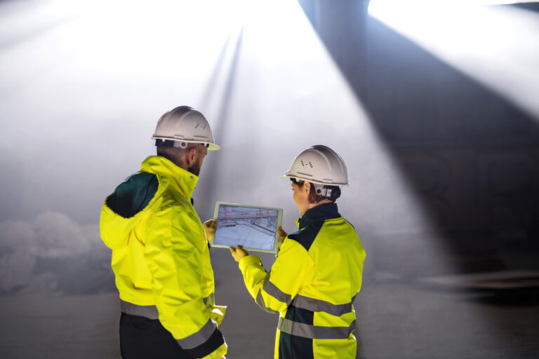
Walking the Job: Image-Based Construction Coordination in the Field
It’s a new day at the jobsite and the project team just completed their first in-place mockup for a block of conference rooms. Next up: a punch walk with the Owner and Architect. As the team heads out, the Project Engineer attaches his 360° camera, launches the OpenSpace app on his phone, and taps record. During the punch walk, OpenSpace AI is busy documenting everything in the PE’s path and will automatically pin the images to the plan.
When someone calls out an issue during the walk, the PE simply snaps a photo to create a Field Note. He adds comments and assigns the notes to the trades responsible—right then and there. Behind the scenes, OpenSpace automatically tags each Field Note to the room they were created in, thanks to the Zones the PE already created.
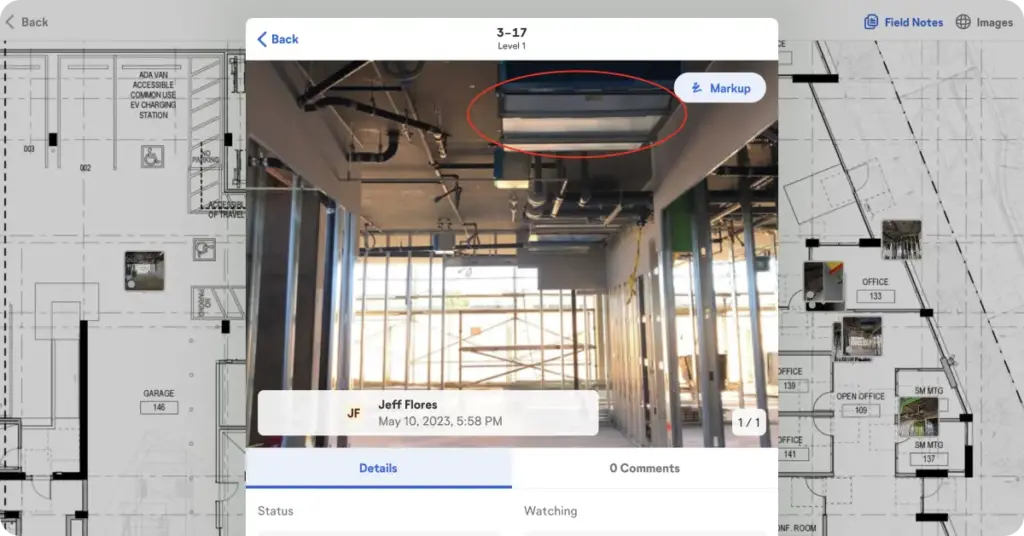
After the walk, the PE quickly generates and sends a PDF report of his Field Notes, summarizing the issues so they can be addressed right away.
Coordinating Design From the Office
Back in the office a Project Manager is reviewing a construction punch list item she was alerted to in a Field Note—it looks like additional MDF board was added to the window covering detail. To get to the bottom of it quickly, she adds the Superintendent to the Field Note. A few minutes later, the Super sends a reply, noting that the window covering install originally looked bad—it was sticking out of the pocket it was meant to be hidden in.
Without needing to go on-site, the PM simply jumps to the OpenSpace images directly from the Field Note. She opens Split View to compare the current condition to a date before the MDF was installed, and easily confirms that the pocket isn’t deep enough to fully conceal the window covering, the original design intent. Back in the Field Note, she adds the Architect to inform him this change was necessary, and closes out the punch item.
Easy BIM Coordination Between the Office and the Field
Later in the day, the PM gets a call from the drywall subcontractor who has a problem with one of his punch items—he’s being asked to remove a furred-out portion of the wall in one of the large conference rooms. Filtering by Zone, the PM finds the Field Note and clicks into the 360° pano viewer to take a look at the latest captures. She can see that a corner in the room was furred out, and the elevation symmetry was lost. The drywall sub explains that his crew had to install it this way to accommodate a plumbing line.
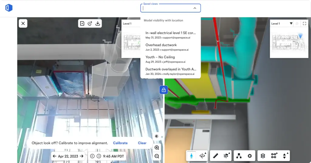
Clicking on BIM Compare, the PM brings up the model to view it side by side with the 360° image. Since the project is also running OpenSpace BIM+, she does a quick overlay of the pipe on the image side and immediately verifies that the pipe is landing outside of the wall.
Resolving a clash on the spot like this is what BIM coordination looks like in practice, when the design and the field condition sit side by side instead of in separate systems.
For easy and clear communication she saves that BIM Compare view with a couple of clicks and shares it with the MEP designers—they can look at the Saved View to adjust their design for future large conference rooms. Sounds like an efficient day so far!
Dive Deeper into Construction Coordination
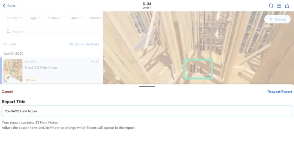
To learn more about easy-to-use tools from OpenSpace for increased efficiencies in the field and office, head to our construction coordination use case page. You’ll find information on how to use OpenSpace to resolve RFIs quicker, better manage issues, and improve change order requests, and more.
Pulling RFIs, issue management, and change orders into one image-based view is what field management workflows look like in practice, with less time hunting for context and more time resolving it.
More to Come!
We’re continuing to deliver new features that improve ease of use and simplify construction coordination in the office and the field. Here’s a list of recent and upcoming enhancements in OpenSpace Capture, announced in this press release.
Available Now:
- Project home screen on desktop: A big improvement to your user experience, discover the new home screen for each project. Immediately see relevant information for easy access: active sheets, latest captures, and recently created Field Notes.
- Capture Paths in the 360° pano viewer: See a visualization of your entire captured path of 360° video. A significant upgrade, Capture Paths delivers simpler, more intuitive navigation that ensures you land where you want—click anywhere on the path to jump to that location. Adjust orientation with ease and choose the color and opacity of your path to ensure the best visibility for the capture you’re in.
- Zones: Create Zones on your sheets that match what you want to track, such as locations or phases of work. OpenSpace automatically tags your Field Notes by the Zones they’re in, making it easy to track and filter. (Keep an eye out for additional Zones features coming to OpenSpace that will further streamline finding the information and images you need.)
Currently in Beta:
- Sheet improvements: In the sheets view, you can now filter by date and capture type to sort your 360° images, Field Notes, and 3D Scans, making it easier to track down what you need from a specific location and time.
- Improved navigation in the mobile app: Part of our continued effort to help you get it done in the field, we added a tab navigation bar at the bottom of the screen, enabling you to quickly jump between Home, Sheets, Field Notes, and Settings. And now in the project browser, fly through your images by easily panning across your sheet and using the time slider to jump to different points in time for a specific location.
- Mobile push notifications: Helping you jump on a problem quickly and stay up to date, you can set up push notifications on your mobile device. Get notified when captures are ready for viewing or when a Field Note you’re assigned to, or are watching, is updated with a new comment.
On the Horizon:
- Overhead captures: Overhead captures are images taken above your head, identified as such by OpenSpace within a capture. This makes it clear and simple to find any images located within a ceiling or another location higher than a typical capture. Note that this feature is not yet in Beta, but we expect it to be generally available in the coming months.
Interested in Learning More?
If you’re an OpenSpace customer and would like to participate in testing for any of the features in Beta, reach out to your OpenSpace representative. If you’re not an OpenSpace customer and you’d like to see how you can take advantage of our reality capture and construction coordination tools, click here to schedule a quick live demo.