We had a great turnout at our New OpenSpace BIM+: Unlock the power of BIM in the field webinar held the same day as the official launch of our brand new package of 3D tools. OpenSpace BIM+ is built specifically for the field to improve BIM coordination. The chat was very active during the webinar and we ran out of time to respond to all the questions live! So we went through the list of unanswered questions and are providing our responses here. (Note that we combined similar questions into one.) First things first, we heard that some viewers experienced low video quality during the webinar, while others did not. The recording looks great, so we recommend watching it on-demand, especially to see the product demos clearly.
Is OpenSpace BIM+ available for existing projects?
Yes! You can add OpenSpace BIM+ to your existing projects. Contact your OpenSpace representative to get started.
What are the pricing or subscription plans available?
OpenSpace BIM+ is an add-on to OpenSpace Capture. Pricing for OpenSpace Capture is by subscription and is customized to meet your needs. To learn more and get a quote for OpenSpace Capture and all the OpenSpace BIM+ features you saw in our webinar, fill out this short form. If you’re already an OpenSpace Capture customer and are interested in OpenSpace BIM+ (or you had free Beta access), contact your OpenSpace representative or support@openspace.ai to discuss your subscription pricing options.
If you download a model on mobile in OpenSpace BIM+, can you access it in BIM Compare?
No, you cannot use a downloaded model in BIM Compare because we do not cache OpenSpace Capture data for offline use. With OpenSpace BIM+ you can cache your BIM model for offline use so that when you’re in the field, you can easily access the model even in low- and zero-connectivity environments. When using BIM offline, you can navigate your model in the app in three ways: (1) sheets-based navigation, (2) Saved Views, and (3) joystick-style navigation for walk-through mode. Find more information in our Support article.
Note: If you’d like us to consider building a feature to cache capture data for offline use alongside the BIM, you can submit this as a request to your OpenSpace representative so we can consider adding it to the roadmap. Keep in mind that OpenSpace 360° video capture files are large, so the storage available on your device will impact how much capture data you can cache. When you submit your request, it would be helpful to note how much capture data you would want to have available offline, so that we can prioritize our development work to suit your use case.
How does the point cloud align with the model/images?
You must align point clouds to the BIM coordinate space prior to uploading to OpenSpace. We leverage that alignment data from the .rcp manifest to locate the appropriate .rcs files relative to the BIM. We do not currently support manually aligning point cloud data to BIM.
Note: If you’d like the ability to manually align point clouds to BIM in OpenSpace after upload, submit that request to your OpenSpace representative so we can consider adding it to the roadmap.
If I want to associate multiple models on a project, do the models have to be for one discipline only, or can I use models from different areas on the project?
You can do both—we support associating multiple models by discipline and by project location! We only require that your models are on the same common coordinate system before you upload them to OpenSpace. For more information on this process, check out our Support article.
Note: We don’t currently support manually aligning models to one another. (Again, you must establish a common coordinate system for all models in the source file prior to upload.) If you’d like the ability to manually align models to one another in OpenSpace after upload, you can submit that request to your OpenSpace representative so we can consider adding it to the roadmap.
What file formats do you support for model imports (e.g., RVT, IFC, DWG, etc.)?
We support all the above-mentioned file formats. Find a full list of supported file formats here.
How large of a BIM model file can OpenSpace BIM+ run?
You can upload models up to 4 GB in size to OpenSpace, however individual models above 1GB in size may load slowly in BIM Compare, so we recommend keeping models under 1GB. If you’re uploading multiple models in OpenSpace BIM+, the total number and size of all uploaded models has no limit, but we still recommend that individual models don’t exceed 1GB. (When selecting which model(s) to load simultaneously in BIM Compare, the viewer will be slow and could potentially crash if too many large models are loaded at the same time.)
Have you done any study with the use of this tech in post-construction?
OpenSpace customers use their capture data in all phases of construction including facilities management. With OpenSpace you can access and navigate a complete digital record of the building. While we haven’t conducted a formal study regarding OpenSpace BIM+ in facilities management we believe these tools will be helpful to view the existing space compared to a proposed new design.
Can only the Admin upload the models into OpenSpace?
Yes, you must be an Org Admin or Site Admin to import models directly into OpenSpace from your local drive or using Autodesk model import. (Model upload and import happens in Project Settings which is accessible to Admins). If you’d like more information on how to import models from Autodesk, check out this Support article.
Note: If you’d find value in giving other user levels the ability to upload or import models from your corresponding Autodesk project into OpenSpace, submit that request to your OpenSpace representative so we can consider adding it to the roadmap.
Where are point cloud and 360° photos stored and coming from?
You can upload your point cloud data in our supported formats (.rcp and .rcs) from your local drive or directly from Autodesk (BIM 360 or Autodesk Forma Build). Uploading directly from Autodesk is the faster method.
Images are from your OpenSpace Capture data. To learn about OpenSpace data hosting and security, head to our website.
Can the OpenSpace 360° pano viewer get up into the ceiling space?
We do not currently support the ability to view varying heights in your OpenSpace captures, but we’ve received the request for this functionality in the past and are actively looking into it. (Also, note that with our BIM Element Overlay feature in OpenSpace BIM+, we do support some Z height variability in BIM Compare alignment.)
What laser scanning equipment is compatible for point clouds in OpenSpace BIM+?
You can upload your point cloud data from Autodesk (BIM 360 or Autodesk Forma Build) regardless of what device you used to take the scan. Our only requirements are that you align the point cloud and your BIM model to the same common coordinate system prior to uploading, and that your point cloud is in our supported formats (.rcp and .rcs).
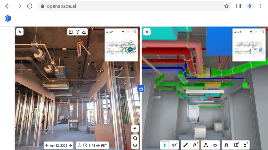
Am I understanding that capturing with OpenSpace now captures a point cloud instead of 3D imagery? And this point cloud can be integrated with the BIM model?
Documenting your jobsite with OpenSpace Capture still works as before—your 360° video automatically maps to your floor plan and you can add 360° photos. New in OpenSpace BIM+ is the ability to import a point cloud taken outside our system with your own laser scan tool. After importing, you can view the point cloud side by side with your 360° images or overlaid with your model in BIM Compare.
Note: We don’t currently support the ability to view a point cloud from your OpenSpace 360° video capture in BIM Compare. If you’d like to request this functionality, submit it to your OpenSpace representative so we can consider adding it to the roadmap.
Can you capture point clouds directly in the OpenSpace platform?
We support importing laser scan point cloud data from any laser scan tool. In OpenSpace Capture we have a 3D Scan feature that enables you to use a LiDAR-enabled smartphone or tablet to generate a mesh from a point cloud and take measurements from that mesh.
We don’t currently support the ability to view the raw point cloud from a 3D Scan or from a 360° video capture. If you’d like to request this functionality, submit your request to your OpenSpace representative so we can consider adding it to the roadmap.
What is the tolerance for BIM Element Overlay?
Various factors impact the accuracy of the alignment in the overlay state, including (1) if a suitable default model was not set prior to capture and therefore our AI algorithm has not run, (2) if the capture conditions lack sufficient similarity to the corresponding BIM views, our AI algorithm will not be as effective, and (3) if the person capturing experienced a lot of elevation changes during the capture (common in civil projects), it’s likely that the Z height variation of that capture will have a negative impact on BIM Element Overlay accuracy. If any of these three factors prevent accurate automatic alignment, then you can use our manual calibration tool to manually calibrate and therefore improve the alignment accuracy of a given frame in your capture. (See the “How to use BIM Element Overlay” section in our Support article for information on manual calibration.)
Ready to Learn More?
If you’d like to talk with us about getting more value from your models and to get a demo of OpenSpace BIM+, let’s talk!