2025: An inspirational year of innovation & building
As the year wraps up, I want to say something pretty simple: ...
October 15, 2025
Over 600 people from the construction industry tuned in to Waypoint 2025 where we announced how we’re moving beyond reality capture by transforming into a Visual Intelligence Platform. A unified system of work that moves beyond reality capture to power faster, better-informed decisions that reduce risk and help you get work done more efficiently.
This blog answers questions from our live chat during Waypoint. If you’d like to watch or rewatch any of the sessions, the recordings are available on demand.
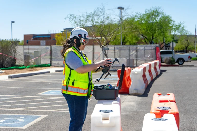
OpenSpace Field is currently available in early access to select customers. Fill out our form if you’re interested in learning more. (During the event we unveiled OpenSpace Field with exciting new capabilities like AI Autolocation.)
AI Search on photos is currently available in English. AI Voice Notes and its transcription are currently available in the following languages: Danish, Dutch, English, French, German, Hindi, Indonesian, Italian, Japanese, Norwegian, Portuguese, Russian, Spanish, Swedish, and Turkish. (If you’d like to request support for another language, please contact your OpenSpace representative.)
Note that our OpenSpace platform is localized in English, German, Japanese, Spanish, Simplified Chinese, and Traditional Chinese.
The more captures, and the better the coverage, the better. But to get started, you only need one. Our technology relies on the sensors on your smartphone and its camera to build out our sensor map, which allows a user’s device to locate them in the project space. To learn more about how AI Autolocation works, see our CTO’s blog.
We’ve built in a “floor change detection” algorithm that indicates when floor or elevation changes occur. This means you’ll be prompted to switch sheets. In the future, as we continue to build on and improve this system, floor changes will become more fluid and accurate.
You will pin your first Field Note. After that, AI Autolocation will follow you and suggest a location for each Field Note thereafter—no need to keep your phone or camera out.
We expect that OpenSpace Air will be able to ingest drone video later this year.
RTK (real-time kinematic) is already supported today—correction data is included in the image metadata. We expect to support GCP (ground control points) later this year.
Legal requirements for where you can fly drones vary from city to city. We definitely recommend you research and follow local and federal drone laws in your area before flying.
We currently use GIS (geographic information system) data in OpenSpace Air and our new OpenSpace Field features. We plan to continue exploring additional places to integrate GIS in our platform.
With OpenSpace Progress Tracking we track your production rate with the speed of AI and the accuracy of experienced professionals.
Yes, our Usage API works great with Microsoft Power BI. You can take advantage of our Usage API and Power BI template to develop custom reports on OpenSpace data. The data is delivered in a structured, simple format. Find details in our Support article.
Our upcoming Field Note APIs will enable you to integrate your Field Notes in OpenSpace with any platform you want. Also, we plan to continue building new integrations. Stay tuned for future announcements.
Today, our APIs support GET endpoints for most fields, meaning you can take data out of OpenSpace. POST and PUT endpoints will come later, which will allow you to build a connection that works bi-directionally (two-way sync, where data stays aligned in both systems).
The new OpenSpace BIM Viewer supports dozens of file types including .NWC and .NWD; find a full list of supported file types on the Autodesk Platform Services website. NWF files are project containers, not true 3D model files, so they cannot be read outside of the Navisworks program. But please reach out to your OpenSpace representative so that we can learn more about your workflow and see how we might work to get your model data into the OpenSpace Visual Intelligence Platform.
Models from ProjectWise and Aconex must be exported into one of our supported file types and imported into our platform.
Yes, you can use our Autodesk Model Import feature in OpenSpace BIM+ to pull your model directly from ACC into OpenSpace—and pull in new versions as the model is updated with one click. Learn more in our Support article.
AI Image Enhance automatically sharpens, adjusts contrast, and corrects blur and visual noise on your captures. Our technology will not hallucinate any extraneous imagery in your capture. See our Support article for details on enhancing 360° captures.
Yes, if you’d like to incorporate your OpenSpace 360° imagery into your GIS platform, please reach out to your OpenSpace representative so we can learn more about your use case.
Here are links to the recordings of each Waypoint 2025 session, and some additional resources about all the exciting announcements we made: