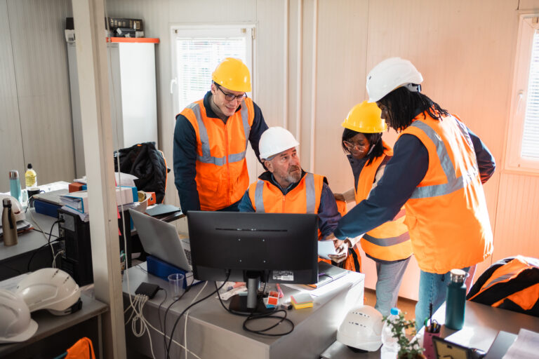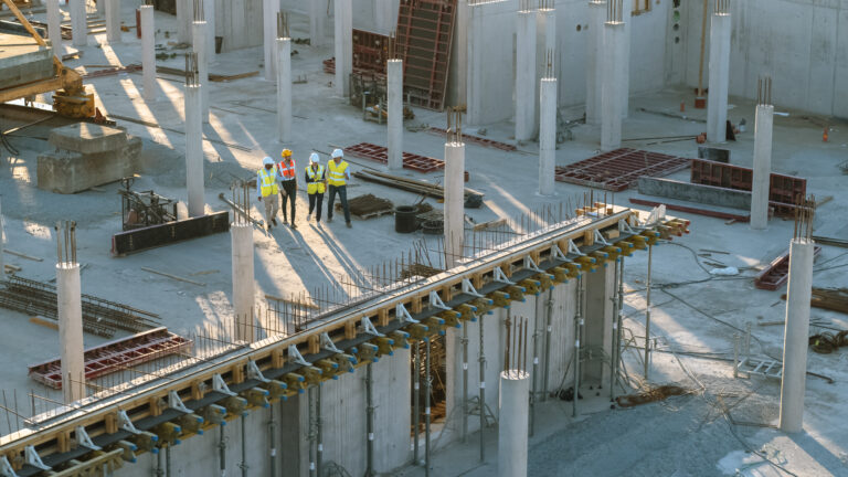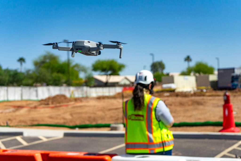
Every week on a construction site, your team is making decisions with incomplete information. A drone survey changes that equation fast. In the time it takes a ground crew to set up equipment and walk one corner of a site, a drone can cover the whole thing, capturing high-resolution aerial imagery that gets turned into orthomosaic maps, 3D models, point clouds, and elevation data within hours.
For general contractors managing complex schedules, tight budgets, and multiple trades, that kind of speed matters. But the real shift happening across the construction industry isn’t just about faster capture. It’s about what builders do with that aerial intelligence once it’s in their hands.
The drone survey has evolved from a novelty into a core layer of Visual Intelligence for project teams.
What is a construction drone survey?
A construction drone survey is the process of flying an unmanned aerial vehicle over a project site to capture georeferenced aerial imagery, which is then processed into usable outputs for construction workflows.
Unlike traditional surveying methods that require ground-based instruments, total stations, and extensive setup, you can complete a drone construction site survey in a fraction of the time with comparable or better accuracy for most commercial applications.
The primary outputs of a drone survey include:
- Orthomosaic maps: high-resolution, georeferenced aerial images stitched into a seamless top-down view of the construction site.
- 3D models and point clouds: detailed three-dimensional representations of site conditions, structures, and terrain.
- Digital elevation models: surface models showing height variation, drainage patterns, slope, and cut/fill context.
These outputs feed directly into construction workflows: grading plans, progress comparisons, earthwork calculations, QA/QC reviews, and stakeholder reporting. For you and your VDC lead, it’s a cleaner, faster way to see exactly where your project stands.
The technology behind a construction drone survey
Understanding what makes drone mapping work helps builders evaluate the right approach for their projects. The quality and usefulness of drone survey outputs depend on three things: the sensors on the drone, the processing methodology, and how the resulting data integrates with existing construction workflows.
Sensor type: photogrammetry vs. LiDAR
| Photogrammetry (RGB camera) | LiDAR sensors | |
| How it works | Captures overlapping high-resolution images and processes them into maps and 3D models | Uses laser pulses to measure distances and build dense point clouds |
| Best for | Open sites, progress documentation, orthomosaics, surface models | Dense vegetation, complex terrain, high-accuracy vertical measurement |
| Outputs | Orthomosaic maps, point clouds, 3D models, digital elevation models | Dense point clouds, bare-earth models, LiDAR data for structural analysis |
| Cost and complexity | Lower cost, widely accessible, most commercial drones support it | Higher cost, specialist equipment, delivers high-accuracy outputs in challenging conditions |
Key terms to know
RTK (Real-Time Kinematic): corrects GPS positioning during the flight, delivering centimeter-level accuracy without post-processing.
PPK (Post-Processed Kinematic): corrects GPS positioning after the flight. Offers similar accuracy to RTK and is useful when real-time signal is unreliable.
GCPs (Ground Control Points): Survey markers with known real-world coordinates used to georeference drone imagery and improve absolute positional accuracy.
GSD (Ground Sampling Distance): The real-world size represented by each pixel in the captured image. Lower GSD means higher resolution and more precise measurements.
Accuracy depends heavily on methodology. Drones equipped with RTK or PPK technology consistently achieve horizontal accuracy within 1-3 cm for most commercial construction applications, meeting engineering and compliance standards.
The ISPRS Annals (2024) published research confirming that RTK-enabled UAV photogrammetry delivers direct georeferencing accuracy suitable for construction and engineering use. Flight altitude, camera specs, and overlap settings all influence GSD and, ultimately, how usable the final deliverables are for construction site decision-making.
The benefits of drone surveys for construction projects
The case for drone surveys over traditional surveying methods isn’t just about speed, though the time savings are significant. A site that would take a ground crew several days to survey can be covered in a single drone flight. The deeper benefits are about accuracy, repeatability, and reduced exposure to risk across the project lifecycle.
Faster data collection with fewer resources
Traditional land surveying requires significant labor. Crews with total stations and GPS receivers walk the site methodically, collecting point-by-point measurements that take days to compile.
A single drone flight covers the same ground faster, and processing happens automatically in the background. Drone pilots can capture large, complex sites that would take ground crews significantly longer to cover using conventional methods. The result is more frequent, consistent surveys without a proportional increase in cost or labor.
Centimeter-level accuracy at scale
When drones equipped with RTK technology and proper GCPs are used correctly, the data accuracy they deliver rivals traditional methods for most construction applications.
Centimeter-level accuracy in orthomosaic maps and 3D models means builders can take precise measurements, run earthwork calculations, and verify site conditions with confidence. For topographic surveys, grading verification, and volume calculations, that level of precision is what separates useful aerial insights from aerial photography.
Improved safety & access to hard-to-reach areas
Some of the most valuable areas to survey on a construction site can be the hardest, or most dangerous, to reach. Drone surveys eliminate the need to send people into these areas or up on scaffolding or lifts to capture inspections and measurements.
Roof inspections, facade reviews, and jobsite surveys can all be done remotely. That means fewer people in risky situations, and fewer safety exposures across your project.
Repeatable results across the project lifecycle
Drone surveys aren’t just a one-time snapshot—they’re most powerful when repeated over time. With a consistent survey cadence from preconstruction through closeout, you build a time-stamped visual record that supports progress tracking, dispute resolution, payment verification, and owner reporting.
Repeatable flights on the same path ensure that changes between surveys reflect actual site conditions—not inconsistencies in how the data was captured.
“We used to rely on site walks and gut feel to track progress on complex scopes. Drone surveys replaced that with hard data. Once your team has flown the same site a dozen times, the aerial record becomes your single source of truth for everything from owner reporting to claim defense.”
– Enrique Amaya, Sr. Solutions Engineer, OpenSpace
Why builders are moving fast on drone adoption
The construction drones market was valued at $4.6 billion in 2024 and is projected to reach $7.1 billion by 2030, growing at a compound annual growth rate of 7.7 percent, according to Research and Markets. The factors driving that growth track closely with the pressures general contractors face every day: labor shortages, tighter margins, and the need to make faster, better-informed decisions on-site.
And construction industry labor shortages aren’t easing. A projected deficit of more than 439,000 workers in 2025 means that you’re expected to manage more with fewer people. Drone technology helps close that gap by automating data collection tasks that would otherwise require dedicated survey crews.
If you’re managing reporting, progress documentation, and quality control across multiple projects, drones reduce the manual inspection burden without reducing the quality of information coming in.
Integrating drone intelligence with BIM software has accelerated adoption significantly. When drone mapping outputs like orthomosaics and point clouds can be brought directly into project management platforms, the investment case becomes much clearer. It’s not a standalone cost; it’s a multiplier on existing systems.
What can drone surveys actually do on a construction site?
Drone surveys in construction go well beyond aerial imagery. For general contractors and trades, they solve five specific, high-impact workflow challenges.
Drone surveys in construction go well beyond aerial imagery. For general contractors and trades, they solve five specific, high-impact workflow challenges.
Preconstruction planning & site logistics
Run a drone survey before a shovel hits the ground to establish a reliable baseline. Orthomosaic maps and topographic surveys from preconstruction flights inform grading plans, site logistics, crane placement, staging area design, and utility routing. You can take accurate measurements directly from the imagery and overlay design drawings to compare planned versus existing conditions before construction starts.
Earthwork, grading & cut/fill analysis
Manual earthwork tracking is slow and prone to error. Drone mapping streamlines the process: regular survey flights combined with digital elevation models enable site engineers to quantify cut/fill volumes, monitor stockpile volumes, and verify grading progress—without extensive ground-based measurement.
Exporting this data into tools like Civil 3D and ArcGIS integrates survey outputs directly into engineering workflows. With OpenSpace Air, you can process elevation models and cut/fill analysis from standard drone flights and export results into tools you already use— specialty hardware or complex workflows required.
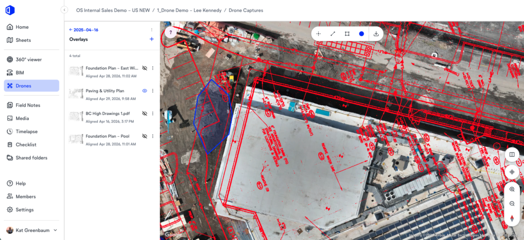
QA/QC with plan overlays
Overlay design drawings onto orthomosaic maps to compare planned versus what’s been built at scale. Misalignments in foundations, utilities, and structural components that are often hard to spot from the ground become immediately visible. Run regularly, this approach catches issues early, before they turn into costly rework.
Progress tracking & schedule comparison
A series of drone surveys over time gives a clear, objective view of construction progress. Comparing one flight to the next shows exactly what’s changed, where work is advancing, and where it’s falling behind. This perspective is espeically valuable for exterior and civil work scopes, where ground-level capture alone doesn’t provide full visibility.
Stakeholder & owner reporting
High-resolution drone imagery keeps owners, developers, and investors informed about construction progress. Annotated orthomosaic maps and 3D models make site conditions easy to understand for anyone—not just those on-site every day—reducing the back-and-forth that comes with verbal or text-heavy updates.
The problem with drone surveys living in a silo
Here’s where your team might be leaving value on the table: you run drone surveys, get solid outputs, and then those outputs sit in a separate platform that nobody else on the team can easily access or act on.
The typical workflow looks like this:
- The drone pilot runs the flight
- Outputs go into a standalone mapping tool
- You get a PDF or a link
- The intelligence stops there
Nothing connects the aerial view to the ground-level 360° captures happening on the same project, no tie to the project schedule, and no way to track how the aerial view is changing week over week without manually comparing files.
This is the core limitation of treating drone technology as a standalone solution. The construction site is one continuous environment. The information coming from above and the information coming from inside need to live in the same place to become genuine Visual Intelligence. Separate platforms create separate workflows, and separate workflows create gaps in the project record.
If you’re managing multiple projects, that fragmentation compounds:
| The symptom | The real cost |
| Outputs live in a separate mapping app | Aerial intelligence is disconnected from project schedules and ground captures and teams juggle multiple logins and platforms |
| Reporting means manual file comparisons | Progress visibility depends on one person doing the legwork |
| Adoption is inconsistent across projects | The technology delivers less value the less it gets used |
These are the problems OpenSpace was built to solve. By bringing drone imagery, ground-level 360° documentation, and laser scans into a single Visual Intelligence Platform, builders get one place where all their reality data lives together. Connected to the same project record and accessible to every team member without an extra login or an extra contract.
From drone survey to real-time site intelligence
Drone surveys are most valuable when they’re part of the bigger picture—not siloed in a separate tool. OpenSpace Air brings drone imagery into the same Visual Intelligence Platform where 360° captures, smartphone photos, and laser scans already live, so everything lives in one place and works together.
Here’s how it works:
- Any drone, any flight app: Use the hardware and workflows you already have. No specialized equipment needed.
- Processed in hours, not days: Upload images after a morning flight and get results back by lunch.
- Virtual control points: Keep captures from multiple flights aligned automatically, so measurements stay accurate.
- One platform, one login: All your project imagery lives in one place with easy access. Complete clarity and more efficient field workflows.
Scott Wyatt, Project Executive at Gilbane Construction, described the impact of bringing drone data into OpenSpace:
“With the drone data integration from OpenSpace, we can now expand outside the four walls of a building to show things that we weren’t able to see before, from an extremely valuable perspective. Overall, being able to identify items on the project earlier and create efficiencies in our platforms is a big win.”

Want to see OpenSpace Air in action? Request a demo and see how your drone data can become part of a complete construction site intelligence workflow.
What to look for when evaluating drone survey software for construction
Not all drone data platforms are built for construction workflows. If you’re a general contractor or trade evaluating options, here’s what to consider.
| What to look for | Why it matters for construction |
| Drone agnosticism | The platform should work with any hardware and any flight app. Requiring proprietary drones adds cost and limits flexibility in the field. |
| Processing speed | Outputs that take days to process create workflow gaps. Look for platforms that deliver orthomosaics, 3D models, and point clouds within hours of upload. |
| Ground-to-sky capture in one place | The platform should support aerial imagery alongside 360° walkthroughs and other ground-level capture like smartphone photos, so construction workflows don’t have to span multiple apps. |
| Export and compliance capabilities | For projects where aerial survey outputs feed into civil, GIS, or survey workflows, the ability to export orthomosaics, point clouds, and 3D mesh files in standard formats is essential. |
| Field-first simplicity | Construction teams shouldn’t need specialist training to access and use drone outputs. If getting value requires dedicated drone pilots or specialist training, your team won’t stick with it. |
“The mistake I see most from construction teams is buying into a technology without buying into the workflow. Teams fly once, get impressed, and then never build it into their process. Pick a cadence, stick to it, and make sure the outputs are accessible to more than one person. That’s when it actually pays off.”
-Enrique Amaya, Sr. Solutions Engineer, OpenSpace
If you’d like to see how OpenSpace Air fits into your current workflow, grab time with one of our experts.
Frequently asked questions
How accurate is a drone survey?
Drone construction site surveys can deliver centimeter-level accuracy when the right methodology is applied. Drones equipped with RTK or PPK GPS correction systems, combined with ground control points, consistently achieve horizontal accuracy within 1-3 cm for most commercial construction applications. Sensors, flight altitude, image overlap, and processing software all influence accuracy.
For most construction site applications, including earthwork calculations, grading verification, and progress documentation, RTK-enabled drone surveys match or exceed the precision needed.
How long does a drone survey take?
Flight time for a commercial construction site typically ranges from 30 minutes to a few hours depending on site size, complexity, and the level of overlap required. The bigger variable is processing time. Traditional drone software could take days to deliver usable outputs.
With OpenSpace Air, images take typically just 2-4 hours to process into high-quality orthomosaics, 3D meshes, and point clouds, for flights under 300 images, keeping project teams moving without waiting on deliverables.
Can drone surveys be used on projects without BIM?
Yes. Drone survey outputs are useful with or without a BIM model. Orthomosaic maps, digital elevation models, and point clouds provide value for site planning, progress documentation, and earthwork analysis on projects of all types. When a BIM model is available, you can overlay it directly onto drone imagery to compare design intent against actual site conditions, but BIM is not a prerequisite for getting meaningful intelligence from aerial capture.
Make drone data part of how you run your project
Drone surveying isn’t a specialty anymore—it’s quickly becoming a part of how competitive general contractors run projects. The technology is accessible, the outputs are genuinely useful, and teams that don’t adopt it feel the impact in slower decisions, more disputes, and avoidable rework.
You get the most value when your drone data connects to the rest of your visual data in a single, intuitive platform. That’s where drone surveys become something your team can act on, not just another dataset sitting on the side.
See what your projects look like when aerial and ground data come together. Request a demo of OpenSpace Air today.